

"Mini Epic," I guess that's an oxymoron. That's fitting after today's ride. I feel a bit like a moron.
I was finally able to do the Mica Peak climb I was hoping to do a couple Fridays ago. I had the rare occurrence of having a crummy ride. There were lots of contributing factors.
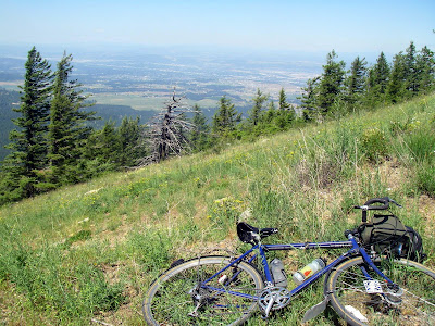
The biggest reason was that I ran out of water way too early and pushed it too far without water. I was about 3/4 up the hill when I ran out of water. But I was so close. I knew there wouldn't be water at the top -- yet I kept going. Dumb.
My knee has been bugging me a bit lately. Normally I stand on long climbs like this and just take it slow, but there was an inch or so of loose gravel and the grade was crazy steep. So I couldn't engage the rear wheel unless I sat down. My RB-T is not geared for spinning up climbs. For rock stars it would be fine: 30/28; but for me that's grinding. So my knee paid for that -- not having gobs of water didn't help the knee either I assume. So that was stupid too.

As I bombed down the other side, which was really an old road: bigger than a trail, but narrower than a road, my camera popped out of my handlebar bag. It popped out because I didn't close the pocket it was in. Of course I didn't see it. This required an hour of back tracking UP the hill again... only to find it about 100 feet from where I had started to back track. By this time I was beginning to feel a bit lightheaded for lack of water. Lame.

I finally ran across some water trickling down the side of a hill. I drank two bottles worth w/out treating it. (Sounds lame, but I trust water that comes out of the side of a hill, especially if there's no grazing up above. But we'll see, maybe my next blog post will be about how I stayed up puking all night.)

I got off course and a bit lost for while. I only packed a GPS. I didn't even bring my Spokane County map. If I had a good map, I would enjoyed the ride down the hill after finding water. Instead, I had to rely on my GPS, which is OK, but not enough. You need the context provided by a map. I got lost for about an hour as the trail got narrower, rockier, and steeper. There were also a lot of fallen trees across the path. Sucky.


I was home by 4:30.
Here's the GPS output:

Lies. Mica Peak is not 5000 feet. I think it's about 4600. But all the same. The climb is pretty severe and packed into about 8 miles.
There's lots to explore in that area; I'll go back next summer and find a better route. I'll also bring more water and a map.
Even though it was not a fun ride; it was still worthwhile. Lots of obvious lessons there that I'm embarrassed to think that I still need to learn.

7 comments:
Sounds like a great, albeit frustrating ride...
What about that ride was crummy? Sounds to me like the kind of great bike adventure we all live for!
The deal about your camera . . .
On our ride up Tower Mt a while back, I got home and my license, credit card and cash were missing. I freaked and had to back-track. Started at SnJ's and re-traced our route. I found them laying on the ground right at the gate, where I had taken my camera out to take a picture and apparently drug them out of my pocket when I grabbed the cam.
Can't tell you how relieved I was that I didn't have to climb all the way back to the top to find em!
Those were some nice views up there on Tower Mt that day. Sad to think what it must look like now.
BTW, screw the racer dude.
Rough time, but makes for a good story...
As a professor of mine said in grad school: "I don't like to write, but I love to have written." I felt the same way last week after riding up to Schweitzer (nine miles and a couple thousand feet plus, but paved). I don't always love the ride, but I love to have ridden.
Oh yeah, as for the elevation, it looks like it's off at the bottom. My gps has my house at roughly 2100. You might be at 2200. I think mine grabs the beginning elevation via satellite but during the ride, it's barometric.
Wow ... quite an adventure! We all make mistakes, don't sweat it. Sorry to hear about all the frustration, but as you said it's not often that happens. A frustrating ride is better than none at all -- trust me, I've done a lot of not-riding recently. Ugh.
Your GPS is accurate. Mica Peak's elevation is 5205 feet:
http://www.peakbagger.com/peak.aspx?pid=3057
Post a Comment