Tuesday, December 8, 2020

Review: Shimano SH-XM9 gore-tex touring cycling shoe

 Just a short 11 years ago, I reviewed the Lake winter cycling shoes. The Lakes are warm boots that were best at very cold and dry conditions. Anything else (i.e. rain/wet) and they're not so great. Their Boa lacing system is one that either you love or hate -- I still think they're solving a problem in bike shoes that don't need to be solved as they do with ski boots. So there. Oh yeah, and the Lake boots don't pass the "may look nerdy, but not bike nerdy" test. 

Enter the Shimano SH-XM9 winter cycling shoe. I got this pair last year and I've given them a sound beating. I'm ready to share my thoughts...

tl;dr

I love em. In all the ways I was disappointed by the Lake shoes, I've been impressed and delighted by the Shimano boots. (They're labeled "shoes" -- by what metric do these meet that definition?)


Let's start with basics: they have laces. That is the correct, proper, and a well-understood way to fasten your boots tightly. Centuries of shoe-tyers can't be wrong! Laces work! Laces Out!

The boots have a webbing strap at the ankle that hold the laces -- coupled with open lace hooks above the ankle and magically strong laces, suffering through the ancient task of manually tying the boots is mercifully efficient. And of course there's a stretchy lace-keeper where you can stuff your tied laces.


As for the "blend in effect" -- they do ok. One thing I always like to find are clothes and shoes that are pretty normal looking and will wear fine in most casual contexts. Although I no longer commute, I still appreciate being able to wear bike-useful clothes as a default mode. This approach makes hopping on the bike for a spin much less of a ritualized event.

I especially don't want to be bikey guy with weird shoes that can barely walk or that looks like Flash Gordon. So while these are some generically damn nerdy looking boots, they're not bike-specifically damn nerdy, and that tiny sliver of difference is all it takes!


Cold? check. Wet? check. Even warm and summer? works -- a bit steamy, but passable. I'm not gonna carry on about the magic that is Gore-tex, because I bowed down long ago. There's a lot of snake-oil charleton bullshit claims of "breathable AND warm when wet" that are just bunk. Gore-tex -- especially in footwear, puts out. 

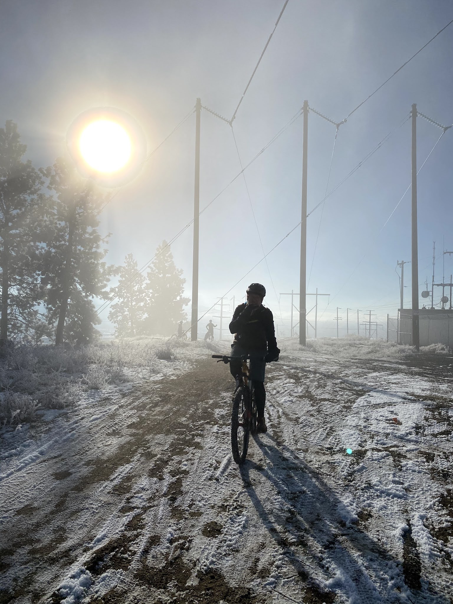
I wear two layers of thin wool dress socks with these suckers and I'm always warm. Pic above is buddy Joe at about 25F on top of Beacon Hill. This is proof that I've been outside with these boots when it was cold. 

For rain -- I learned in a misery fest ride in early fall on a rainy-assed climb on the Kettle Crest Trail that I need to make sure the upper cuff is tented with pants or god-forbid gaiters.


See -- that's a normal nerd look. Not a bike-specific nerd look. Boom. They look good after a year's worth of service. And while I don't wear them a lot, when I do, the conditions are either cold or sucky or both. So these guys mostly get hard use. They're wearing well. As they should. They retail for like $200. But looks like you can find them for around $150. Very worth it.


Of course they're SPD (and other lesser cleats) compatible. That's an obvious requirement. 

But guess what else: they actually wear like a normal boot. If you could get over the extra crunching and screeching brought on by hiking over rocks with an SPD cleat installed, you could do actual, real hiking in these. 

Of course, I make this claim as one who is no fan of walking and disdains hiking. Especially up hill: what's the bloody point? you can't even coast down. Nevertheless, a guy could use these to hike, they're comfy and provide manly support.

The summary: good stuff these boots. 

Tuesday, June 23, 2020

Climbing Boulder


I'm not a fast hill climber, but I really like climbing long hills. There's a purposeful monotony to a long climb. So, my main sort of ride when I"m in Ferry County these days is chopping off a chunk of time to do some climbing. If I were all awesome and amped up, I'd use these climbs to work on intervals and to get fast fast fast. But I just don't. I guess that's ok. But I sort of wonder what it would be like to hammer those and get faster.

I've been working on Boulder Pass all spring. I've climbed it about 1/2 dozen times. The last time, I tried it on the single speed. That felt much slower, but according to strava, that was my fastest time up the climb -- but only by 2 minutes.


Boulder is a solid hill. It's 11.67 miles of climbing. There's short steep pitches throughout and a steady grade otherwise. You always feel like you're climbing. The last 2 miles is pitches up fiercely. But given that you're feeling near the top that steep bit at the end isn't too miserable.

The official name of the road is Boulder Creek Road -- super low traffic road. I've climbed for 45 minutes or so without a car in either direction on a Saturday morning. It's a beautiful area to climb through -- at least I feel it is. The road is surrounded by deep national forest. For most of the climb, Boulder Creek is crashing down the mountain next to you. Spring is particularly lush and clean and lovely.


When my dad moved our family to Washington State in 1974, he had come up here in an attempt to escape the demons he met in Viet Nam and to shake off his association from the hard-living life of "hanging iron" in LA during the continued high rise boom.

One of his first jobs in the new rural Washington was working on a crew to pave Boulder Creek Road. About 20 years later, I'd climb this pass for the first time on a bike. It was an unplanned trip -- I had been helping him and my step-brother do some logging near Malo, WA - where he lived. We fought and I took off -- grabbed my bike and rode up and over Boulder through to Kettle Falls. It would take another 5 years or so before we talked again. That's a silly way to be. It's silly to waste time like that.


Climbing up Boulder sort of rinses my head out. This year especially... as I've brute forced my way back into cycling. When I climb up Boulder -- no matter how slowly -- I can blow out a bit more regret; I can remember nice moments; I try to capture lessons that I missed.

And then I get to descend -- back into the present, back to my people who are here now.

Wednesday, June 3, 2020

Bluffing the Heart Rate


I can't seem to get enough of riding the single speed on the High Drive trails lately. I have this perfect 1 hour, 10 mile loop that I've settled into over the last month or so. It's got just under 1000' of climbing and lots of swoopy single track. It's a perfect lunch ride.

I track my rides with a Garmin device and I'm noticing that my average heart rate is dropping over time, though my speed is about the same. I'm around 135 average heart rate for these rides. I think this means I'm getting more efficient. And/or maybe there's something going on with the way I'm forced to grind all climbs on the single speed -- all muscle and not as much heart required?

Until I got this single speed, which used to be my CX bike until Glen made me a newer awesomer CX bike, I was riding the Bluff trails on my mountain bike. I spent a few weeks in February trying to see how much elevation I could get out of a single ride on the trails in under 2 hours. I think the best I did was about 2200 feet. On those rides I was averaging about 150 BPM heart rate.

What's it all mean? I feel like I would get better workouts with that higher heart rate. But I'm enjoying the grind of the Bluff on the singlespeed -- I tell myself I'm building muscle or maybe power? I don't care that much -- because I'm enjoying my rides now, so who cares. But I'm curious about what it all means. I'd like my riding to be improving something. It's fun and that's enough, but I'll take improvements too.


Speaking of improvements. I'm going to make some to the single speed. I want to get it all light and rad and I want to go tubeless. As the Bluff trails have gotten more traffic over the years, a bunch of previously, mostly submerged sharp rocks have been exposed. On a mountain bike you can bomb and be ok. But on a bike with 35mm tires, you gotta run about 55psi to keep from getting pinch flats. That's too hard for finessing some of the most fun sections of trail down there. So tubeless will be happening.

For tubeless I need new rims. I'm also going to put a carbon fork and other carbon bits on this sucker since I plan to race it in the fall and since spending a bunch of money on carbon bits will absolutely guarantee it will go twice as fast, at least.

Saturday, May 16, 2020

McNitt Road Loop

This is an old morning-ride chestnut. It's quick loop with a bit of climb, a bit of dirt, a lot of deer. Only 10 miles. And a kickin' view.


Wednesday, May 13, 2020

Easter Sunday Mine


I've been wanting to check out the Easter Sunday mine for a month or so.

The ~1930's (?) map shows that there was a small mining camp way up in the middle of the woods. Each little square on the map was a structure of some sort -- I'm assuming a place where people lived or perhaps worked.


But if there's a dot that made it to that map, then there was something there in 1930's, which is sort of interesting since according to the report, The Ore Deposits of Northeastern Washington (published 1914), the mine was pretty much done by 1909... kinda makes you wonder what the hey was going on nearly 20 years later up in these structures.

I took Monday off to go check this out. I invited Thomas to go with me. He's the dude in the first pic. As it works, I converged with Thomas online via Instagram. Sometime in the last year, he went to get some work done by Glen, who vetted him and proclaimed him, "a good guy... I really like him." Thomas' Instagram account shows a dude who likes to explore. He's got Mondays off. And I prefer company when bushwhacking deep in the NF. So it was a go.

With Caltopo, I traced the old route from the 30's map into a GPS track and dumped it on my GPS.

According to the FS 2016 map, the old road is long gone. As it turns out, that's only partially true. In real life, the final 1/2 mile or so was actually spot on the red line. And the mapset I was using on my GPS unit was also in error with that fact. Additionally, the road numbers on both newer map sets didn't correspond to the real world in a couple cases. This is a good reminder to have a bunch of map options when playing around in these areas.

You can see all the potential roads in the map shot above there.

Worse pic of all time --especially given the horrific reality of what was way way down that hole: turbid, yellow water and a tunnel that goes surely goes straight into hell.

There's a lot to explore here, and none of the dots on my 30's map lined up with the single miner's cabin that we did find, but the mine detritus was definitely in the right spot. My thinking here is that by spending a bunch of time exploring this area, I'll for sure bump into many unmarked treasures.


This mine was only about 16 miles from our house, the transport stage is a pretty mellow 10 mile paved journey through beautiful farm and forest. Then NF opens up -- we rode about 6 miles of forest road (~ 4 gravel/nice and ~2 proper/gnarly) to get to this mine. We saw a very promising closed off road that requires exploring. I'll be heading back.


Monday, April 27, 2020

More Summit Lake exploration


We drove up into the Summit Lake area last weekend to find some old mines. A couple excellent loops emerged. Specifically, I'm excited about a loop on FS Road 100 off of Summit Lake -- we drove the old jalopy up there and had to put it in 4x4 mode.


As a bike ride, the loop would make a fantastic climb and descent. Some view, some rocky-challenging surfaces and some smooth forest roads. Lots of filter-able water. And of course, not a soul to be seen.


But there's a lot of evidence of past souls. Mines, cabins, tailings, foundations, abandoned steam equipment. Pretty fascinating.


We just caught a tiny corner of this vast mining area -- nearly all of which is on Forest Service land. And is full of abandoned and forgotten roads that need exploring.


Sunday, April 19, 2020

New routes in Ferry County


 I really get stuck in ruts. I like routine.

I've ridden the same general area of Ferry County for about 15 years now: it's a rough square bound by Deadman Creek on the south, Kettle Crest Trail on the west, the Kettle River on the east, and Boulder pass on the north. You really gotta know this area to make any damn sense of that. But it adds up! It's a box that's about 20 miles x 15 miles of fantastic riding, almost entirely in the Colville National Forest.


As I've got back into riding up here this spring, I've dug into the old chestnuts. I'm particularly happy with my early season climbing of Boulder Pass. That's a beaut of a climb. It 17 miles to the top of that pass from my house -- 11.57 miles of that is the climb up 3,338 feet. I've made 5 attempts and got to the top 3 times. I plan to ride that regularly this year.

But there’s a bunch of Colville National Forest (CNF) all around me that I’ve not explored.

So, today I went up to “Summit Lake.” And was rewarded with a fantastic ride — it’s 15 miles to the lake from my door. GPS said it was about 2000 feet of elevation, but it didn’t feel like it. 

On the map below, start at Barstow, head north on Pierre Lake Road and keep going until you hit Summit Lake. The map is there to illustrate the potential. It's like a steaming pile of guts up there: friggin roads everywhere -- and it keeps going like that for 20? 30? miles east. Old mines, ancient roads, endless loops. If I don't come home some day this summer -- look for my body up there.


The chunk of CNF I usually ride, up around the Kettle Crest, is interesting to me because it’s pretty pristine and natural — it’s far from untouched — but there’s just not a lot of historical left overs of human activity. 

The region around Summit Lake and specifically, the area I’ve been eyeing northeast of Summit, is old mining area. About 100 years ago, this neighborhood was booming with mining, a bunch of little towns and camps, and 1000s of people. First gold. Then silver. Then lead. 

I saw a few things I’ll need to go back and explore. Dig this old mining cabin:


Maddie loves exploring old ruins up here. And I love exploring them with her. I've figured out some magic with historical online maps and the garmin GPS software that results in a GPS file with waypoints for schools, houses, mines, etc that existed in 1936 up in this area. We'll be going up there with that situation to find the good stuff.

These stacked rocks! Click for big to see the second stack in the background. Those are not small rocks.

Summit Lake -- according to my CNF fishing map, there's Cutthroat trout in there. I was pondering the fly-rod portage plan as I rode home this afternoon. 

The difference between Ferry County cows and Spokane-area cows? All Ferry County cows stop every-damn-thing and stare at you. Cyclists might as well have 6 heads. Spokane cows don't even lift their heads up when you ride by.

That's a gas station. Well. When it was a gas station, it was probably called a filling station. It's dead in the middle of nogoddamnwhere. I love that kind of shit.

NO NO NO